
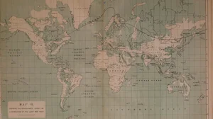
Map II. Showing the approximate effect of a depression of the land 600 feet
1866
About this artwork
This is a detailed cartographic plate from Andrew Murray's 'The Geographical Distribution of Mammals', illustrating the hypothetical impact of a 600-foot sea-level rise on global coastlines.
Did you know?
Andrew Murray was a Scottish botanist and zoologist whose 1866 work provided a foundational look at biogeography before the widespread acceptance of continental drift theories. This specific map explores the potential loss of landmasses due to hypothetical sea-level changes, reflecting 19th-century scientific curiosity about the relationship between geography and the distribution of species.

On your wall. Unlock the HD download and keep this piece in your Vault — forever.
Know the artwork. Knowing its title and artist turns a beautiful image into a story worth sharing — with a museum label:
Map II. Showing the approximate effect of a depression of the land 600 feet
Andrew Murray, 1866